I · THE OBJECT · BRITISH MUSEUM
The Babylonian Map of the World
▶ Listen · narrated
This is a map of the cosmos, not a guide for travellers. It shows where Babylon sat in the order of things — and what lay beyond the edge of the known.
At a glance
- Date
- 6th century BC
- Material
- Clay
- Found
- Sippar, 1882
- Script
- Akkadian cuneiform
Look closer
The river runs vertically
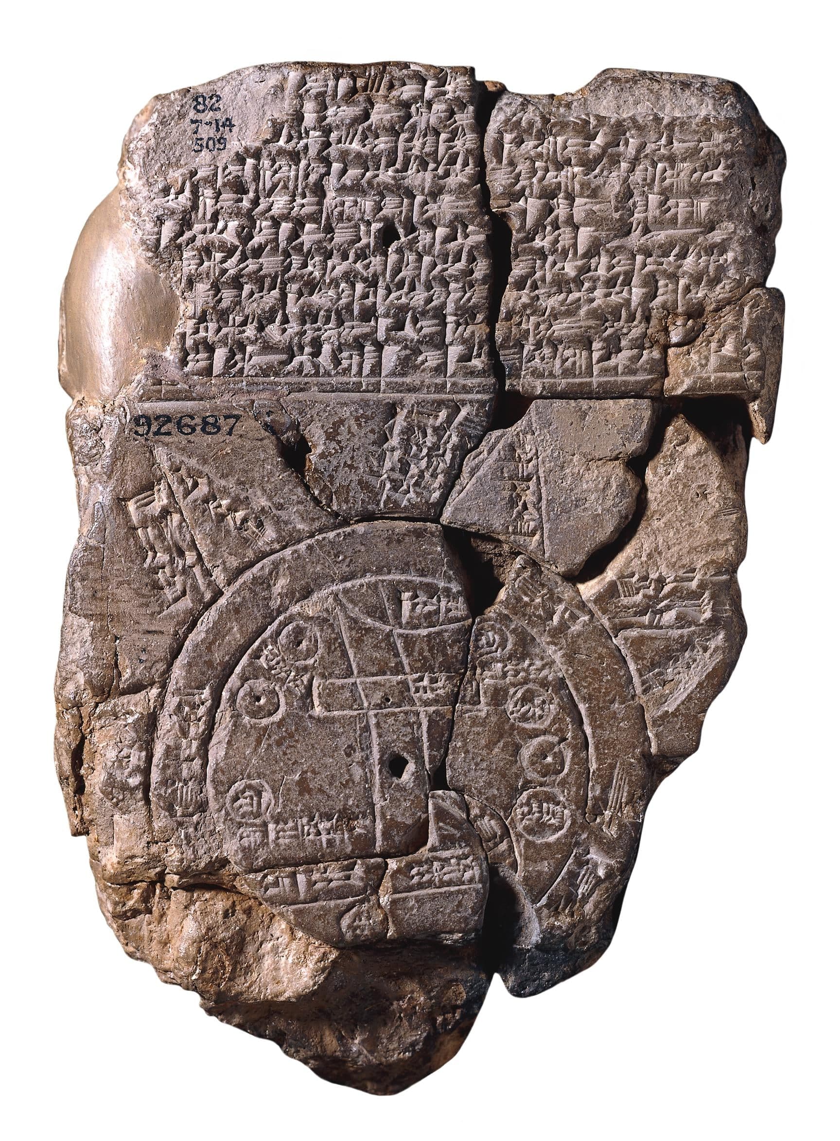
A pair of parallel lines runs from top to bottom down the centre of the disc. This is the Euphrates, flowing from north to south. Its mouth is labelled with two words: swamp and outflow. Babylon sits on the river in the northern half of the circle. The map is oriented with north at the top, like most modern maps, but the organising feature is the river, not a compass bearing.
The bitter river encloses everything
A double ring encircles the land. This is the ocean, labelled in the text as the bitter river. It separates the known regions inside from the triangular sections outside. The triangles project outward from the circle like points on a compass rose, though only a few survive intact. Each triangle represents a distant region, named in an accompanying inscription, though most of those names are now illegible where the tablet is broken.
The cities are named but not mapped to scale
Babylon is marked with a rectangle. Other places — Susa to the south, Urartu to the northeast, Habban to the northwest — are labelled with circles or written names. The positions are schematic, not measured. Habban, for instance, is shown to the northwest of Babylon, but other records place it elsewhere. This is a diagram of relative position and cosmic structure, not a surveyed chart.
The story
The tablet is small enough to hold in one hand. It shows a flat disc of land with Babylon near the centre, the Euphrates running through it, and a double ring of ocean enclosing the whole. Beyond the ocean, triangular sections jut outward — regions whose names the accompanying text once listed, though the tablet is broken and most of those names are lost.
The map is drawn in schematic form. The Euphrates is two parallel lines. Babylon is a rectangle. Other places — Susa, Urartu, Habban — are marked with circles or labels, but their positions are not to scale. Habban, for instance, is shown northwest of Babylon, but that placement does not match other records. The map is not a navigational tool. It is a representation of how the world was thought to be arranged: a disc of known land, a river running through it, an encircling ocean, and beyond that ocean, distant regions imagined as triangular projections.
The text on the tablet, written in Akkadian cuneiform, includes a brief description of the regions and some fragmentary lines about what lies in the triangular sections beyond the ocean. The inscriptions are partly lost where the clay is broken. A piece of the upper triangle was found and joined to the tablet in 1995, but much of the text remains missing.
The tablet was excavated at Sippar, a city about sixty kilometres north of Babylon on the east bank of the Euphrates. It was dug out in 1882 and acquired by the British Museum the same year. The text was translated in 1889. Scholars generally think the tablet was made in Borsippa, a city close to Babylon, though the evidence for that origin is not conclusive.
The date is uncertain within a range. The tablet is assigned to the 6th century BC, though some scholars have suggested it could be earlier, perhaps as early as the 9th century BC, with a late 8th or 7th century date also proposed. The style of the script and the form of the map are consistent with Babylonian work from that period, but no internal evidence on the tablet itself fixes a precise date.
The map does not attempt to show coastlines, distances, or routes. It shows a cosmology: the structure of the world as the Babylonians understood it, with their own city at the centre, the river that sustained them running through the middle, and the ocean forming a boundary between the known and the remote.
Why it mattered then
The map places Babylon at the centre of a world bounded by water. That arrangement is both practical and symbolic. Babylon was the political and religious centre of the region, and the Euphrates was the lifeline of Mesopotamian agriculture and trade. To draw the world with Babylon in the middle and the river running through it is to represent the order of things as the mapmaker understood it. The triangular regions beyond the ocean are not blank. They are named, even if most of those names are now lost. This suggests that the map was not simply a diagram of the known world, but an attempt to account for distant places that were known by report or legend. The map records a structure: inside the ocean, the familiar; outside it, the remote but not the unknowable. The text that accompanies the map includes descriptions of what lies in those outer regions. The surviving fragments mention distances and features, though the full content is unclear. The map and its text together suggest a document that was meant to be read and perhaps consulted, not merely a decorative or symbolic object. It may have been part of a scholarly or priestly tradition of recording and organising knowledge about the world.
Why it matters now
The tablet is a record of how one culture conceived of the world's structure. It shows that the impulse to map — to make a diagram of where things are and how they relate — is not tied to accurate measurement or exploration. A map can be a model of the cosmos, a statement of order, or a way of placing oneself in relation to the unknown. The map has been used as the logo of the academic journal Imago Mundi, which studies the history of cartography. That choice reflects the tablet's status as a document of early geographic thought, even though its purpose and its accuracy are both uncertain. The tablet also raises questions about what a map is for. Modern maps are tools for navigation, for planning, for representing surveyed space. This map does none of those things reliably. It represents a worldview: a flat disc, a central river, an encircling ocean, and regions beyond. It is a diagram of cosmology as much as geography, and it reminds us that the history of mapmaking is not a simple progression from ignorance to accuracy, but a record of different ways of thinking about space, place, and the structure of the world.
The surprising detail
A piece of the tablet was missing for more than a century. The upper-most triangle was broken off, and the tablet was incomplete when it was first translated in 1889. In 1995, a fragment was identified and joined to the tablet, filling in part of the gap. The rediscovery happened more than a hundred years after the original excavation, and it added a small amount of legible text to the inscription. The story of the map's interpretation is still unfolding.
What is disputed
The date of the tablet is uncertain. It is assigned to the 6th century BC, but some scholars have suggested it could be earlier, with dates ranging from the 9th century BC to the late 8th or 7th century BC proposed. The tablet is thought to have originated in Borsippa, but that attribution is not certain. The interpretation of the triangular regions and the fragmentary text remains debated.
How it got here
The tablet was excavated by Hormuzd Rassam at Sippar in 1882 and acquired by the British Museum the same year. Sippar was in the Baghdad vilayet of the Ottoman Empire at the time of excavation. The tablet has remained in the British Museum's collection since acquisition. There is ongoing discussion about the return of archaeological material excavated in Mesopotamia during the period of Ottoman and British presence, though no specific repatriation claim regarding this tablet has been widely reported.
Remember this
A flat disc, a river through the centre, an ocean around the edge, and triangular lands beyond — a map of cosmology, not coastline.
Test yourself
The map shows Habban in a position that does not match other records. Why does that inconsistency not disqualify it as a map?
Because the map is not trying to record surveyed distances or accurate bearings. It is a schematic diagram of relative position and cosmic structure. The purpose is to show where Babylon sits in the order of things, how the Euphrates runs through the known world, and what lies beyond the encircling ocean. Positional accuracy in the modern sense is not the point. The map works as a representation of a worldview, not as a navigational tool. That distinction matters: it means we can learn what the mapmaker thought the world was like, even if we cannot use the map to find our way.
Go deeper
- Babylonian Map of the World · Wikipedia
- Babylonian Map of the pop World — Wikidata · Wikidata
- The Babylonian Map of the World — collection record · britishmuseum.org
Image: Unknown author Unknown author, Public domain. Licence: Public domain. Source.